Thank you for all the new views and likes from last week, it helps keep me inspired.
Starting to take more photos. Still will be posting photos from past trips for a little while longer. Sill a long recovery ahead of me.
Enjoy some more travel photos from past trips.
Sunday, 03/13/2022: Posted photo — Low Key.
Settings: Canon EOS 60D, ISO 2500, f/3.5, 1/40 s, 18 mm.
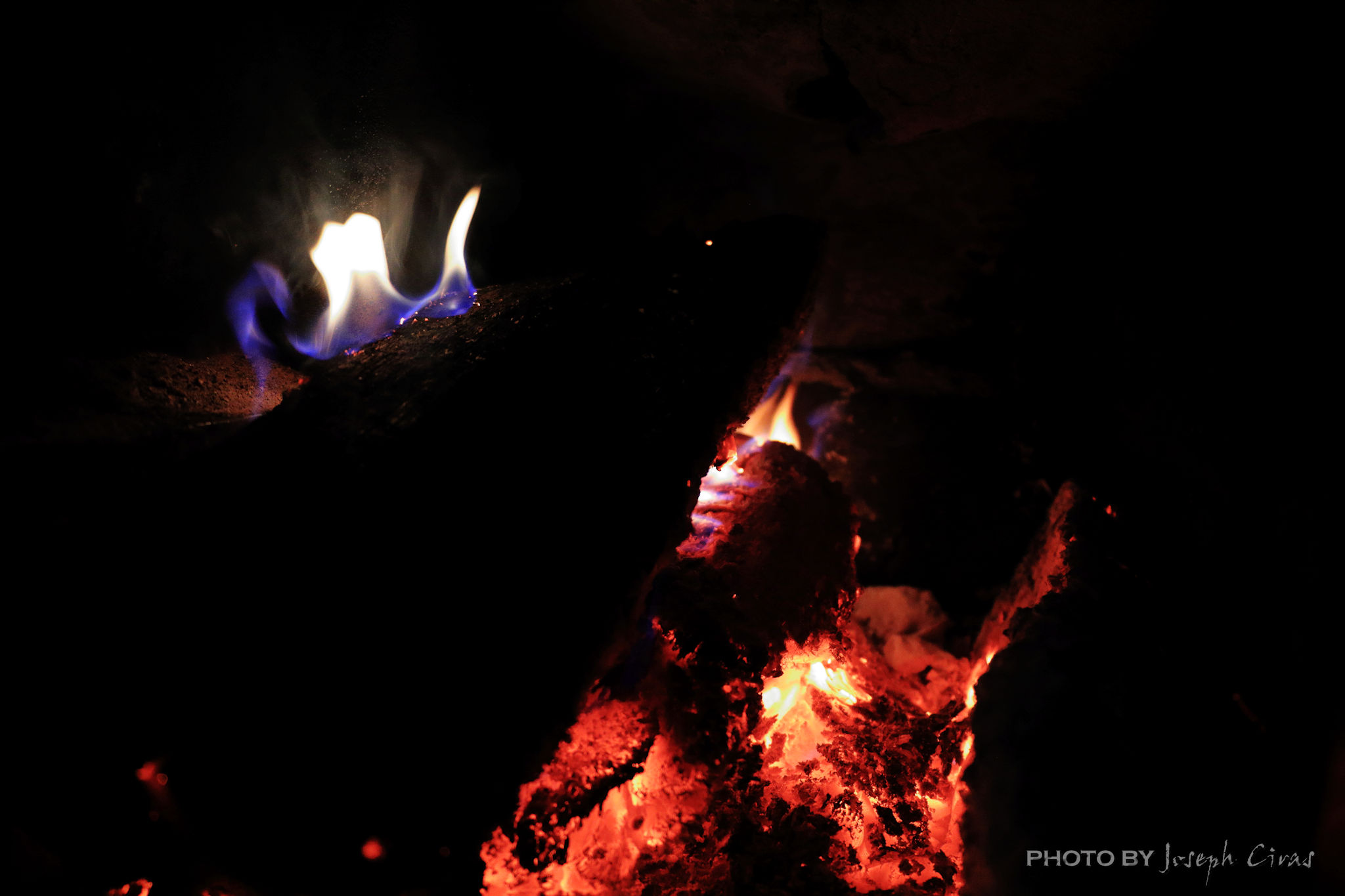
A low key image is one that contains predominantly dark tones and colors. Low key photography conveys atmosphere and mood. One of my photo projects had a low key image challenge this week. I was thinking about what photo to take to meet this challenge. I would have had many options if I had not just been operated on. With limited mobility, I thought about what there might be around the house. Since low key images contain predominantly dark tones and colors, I took a photo of the fire in our wood stove.
Monday, 03/14/2022: Posted photo — Cameron Falls.
Settings: Canon EOS DIGITAL REBEL XS, ISO 100, f/22, 10 s, 28 mm.
Cameron Falls, Waterton Lakes National Park, Alberta.

Cameron Falls is a very uniquely shaped waterfall of about 75 feet in height found in the heart of the Waterton townsite in Waterton Lakes National Park. After heavy rainfall, the waters upriver from the falls get stirred up with a red mudstone called argillite. As the water flows towards the falls, it turns to a beautiful pink hue when light reflects on the mineral water. We did not see the pink falls since the weather was dry when we visited Waterton Lakes National Park just after we visited Glacier National Park in Montana.
Tuesday, 03/15/2022: Posted photo — New Boot.
Settings: Google Pixel 2, ISO 195, f/1.8, 1/60 s, 4 mm.

I had a post op follow-up today a week and a half after surgery. My recovery is going as planned. I was fitted with this very uncomfortable boot. I still cannot put pressure on my ankle for another four weeks. Need to go back on Tuesday for another follow-up since the first one was close to my surgical date and the doctor would like to see my progress and remove some items from my ankle.
Wednesday, 03/16/2022: Posted photo — Harvard Glacier.
Settings: Canon EOS DIGITAL REBEL XS, ISO 200, f/8, 1/2000 s, 160 mm.
Harvard Glacier, College Fjord, Alaska.
The glacier has a 1.5-mile (2 km) wide face where it calves into the College Fjord. It is 300 ft thick and covers 120,000 acres of Chugach National Forest. The Harvard Glacier is the second largest glacier in the Prince William Sound, after the Columbia Glacier.
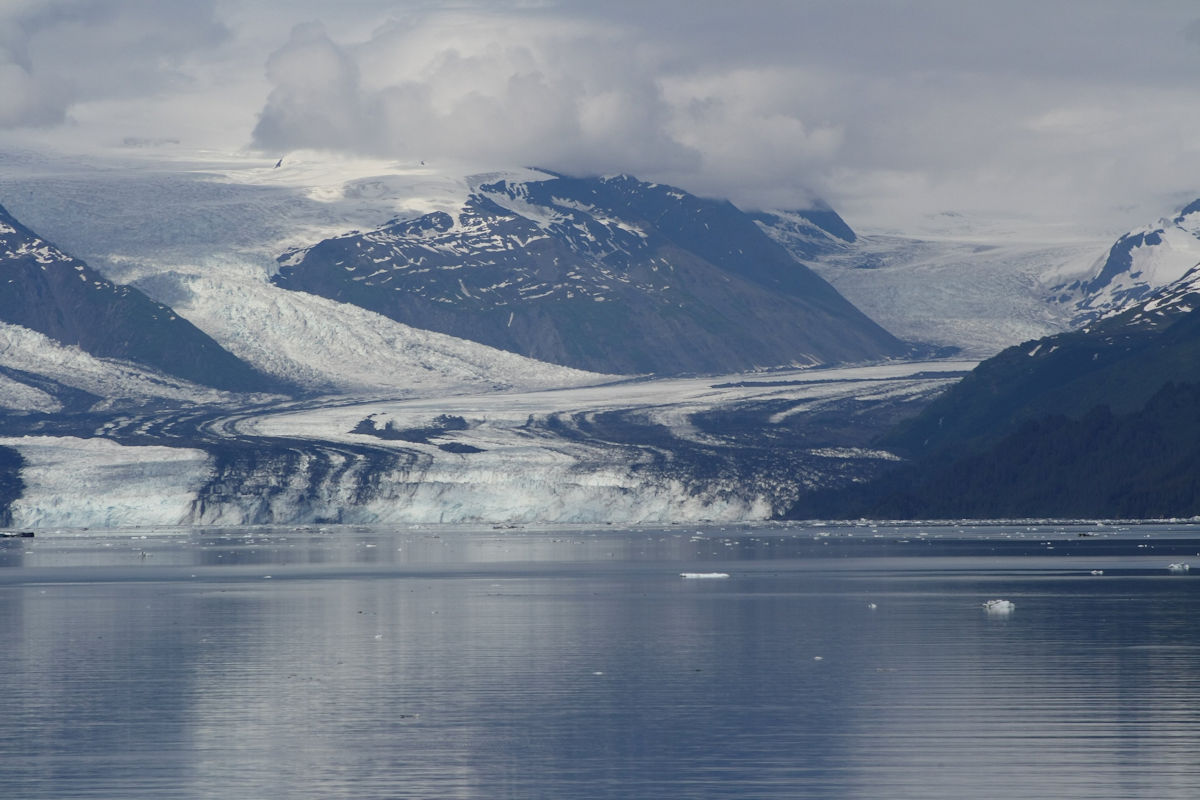
It is amazing to see how large a glacier is when you look at it from a distance. In this photo, we were about a mile from the glacier.
The names of the glaciers in College Fjord are: Amherst, Barnard, Bryn Mawr, Harvard, Smith, Vassar, and Yale. The glaciers of the northwest side feature the names of women’s colleges, and the glaciers of the fork and the southeast side sport the names of men’s colleges. What of Princeton? According to my research on the names, the scholars that named the glaciers took delight in ignoring it since none of them were Princeton alum.
Thursday, 03/17/2022: Posted photo — Cairn.
Settings: Canon EOS DIGITAL REBEL XS, ISO 200, f/11, 1/200 s, 34 mm.
On the trail near the Athabasca Glacier, Jasper National Park, Alberta.
A cairn is a mound of rough stones built as a memorial or landmark, typically on a hilltop or skyline. This cairn is shaped like a person. In Canada this is called an Inuksuk.
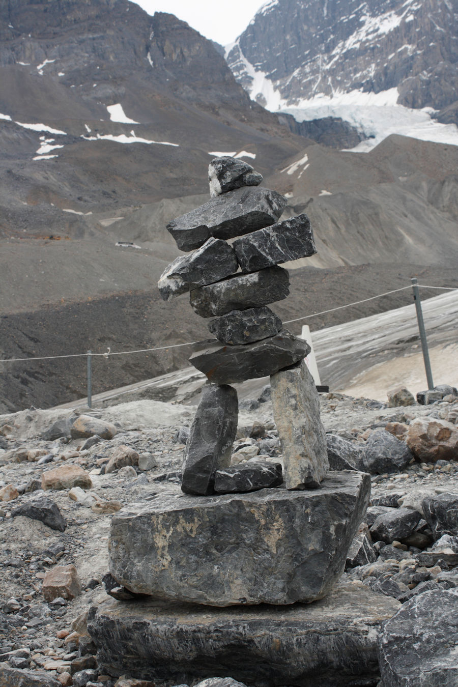
The Athabasca Glacier is one of the six principal ‘toes’ of the Columbia Icefield, located in the Canadian Rockies. The glacier currently loses depth at a rate of about 16.4 feet (5 meters) per year and has receded more than 1 mile (1.5 km) and lost over half of its volume in the past 125 years.
From the Canadian Encyclopedia: “Inuksuk (also spelled inukshuk, plural inuksuit) is a figure made of piled stones or boulders constructed to communicate with humans throughout the Arctic. Traditionally constructed by the Inuit, inuksuit are integral to Inuit culture and are often intertwined with representations of Canada and the north.” — https://www.thecanadianencyclopedia.ca/en/article/inuksuk-inukshuk
Friday, 03/18/2022: Post photo — Pall (and Rekard).
Settings: Canon EOS DIGITAL REBEL XS, ISO 200, f/5.6, 1/160 s, 55 mm.
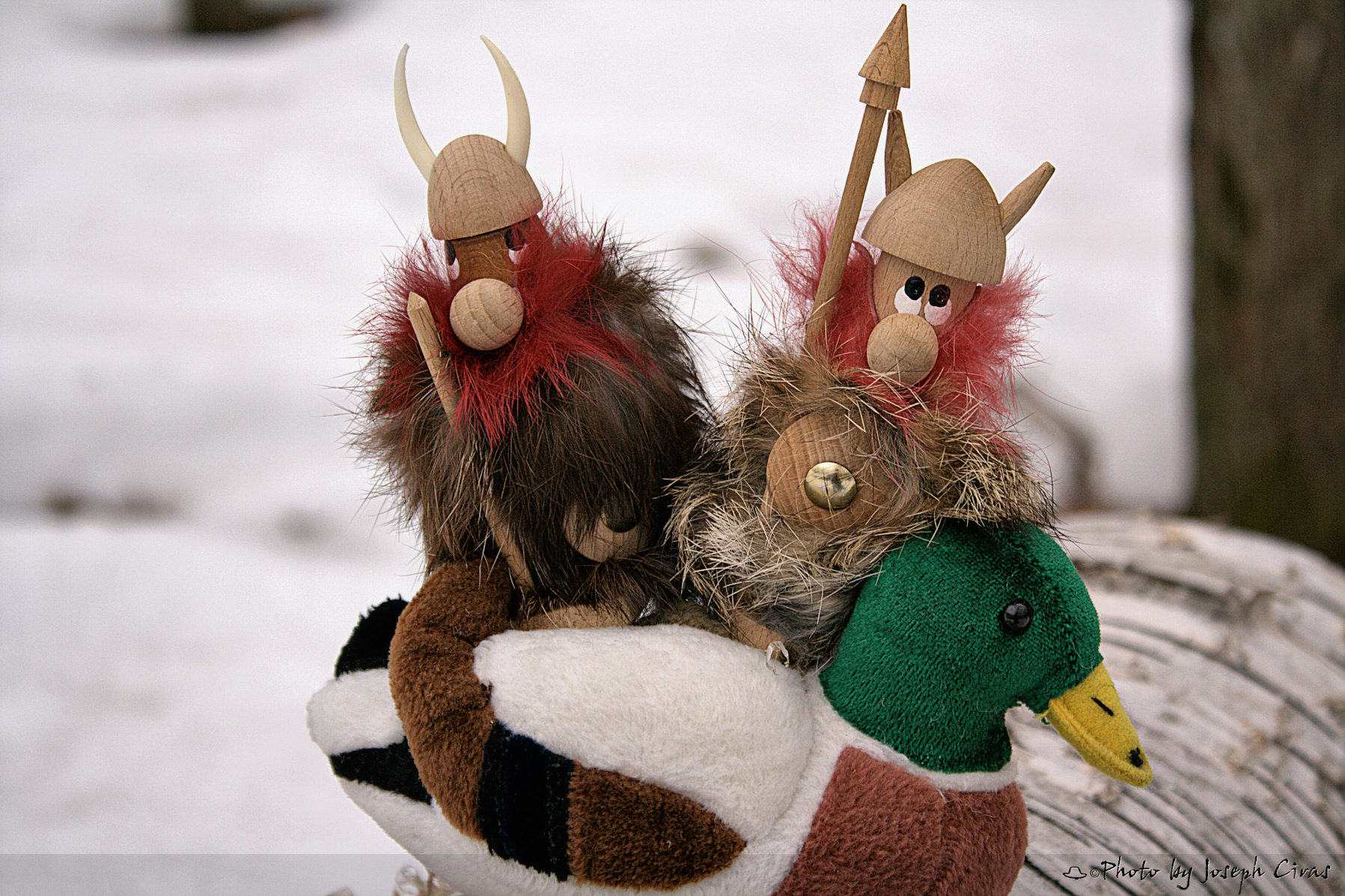
These are my two buddied from Denmark. Earlier on in my photo projects, I featured Pall every week with Pall telling a story about his life. When I went back to Denmark, I picked up Rekard. They ventured together for next year or two. Might be time to bring their adventures back.
Saturday, 03/19/2022: Post photo — Crater.
Settings: N/A.
Mount St. Helens National Volcanic Monument
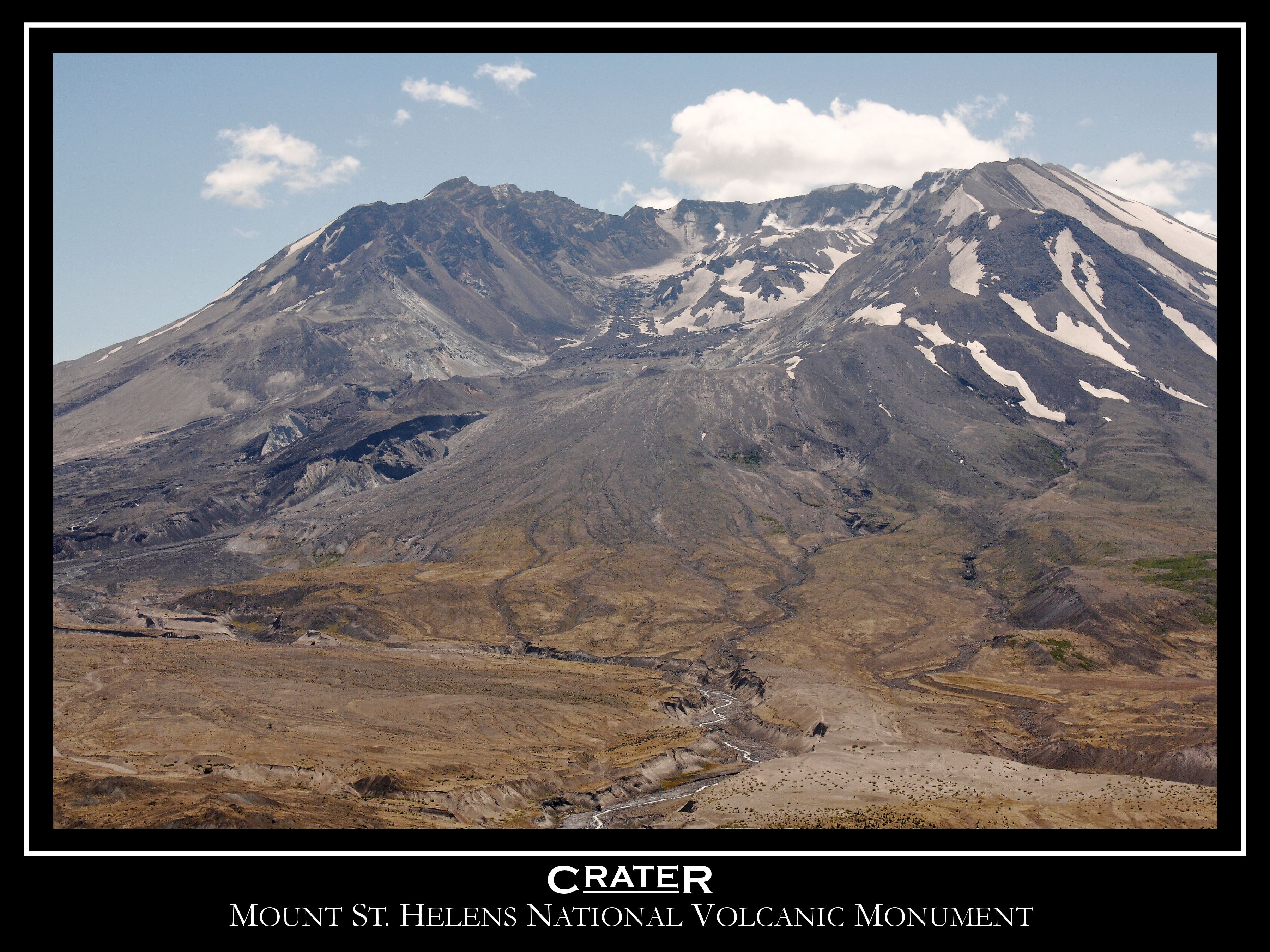
From the USGS:
“Prior to 1980, Mt. St. Helens had the shape of a conical volcano sometimes referred to as the Mount Fuji of America. During the 1980 eruption the upper 400 m (1,300 ft) of the summit was removed by a huge debris avalanche, leaving a 2 x 3.5 km horseshoe-shaped crater now partially filled by a lava dome and a glacier. It is primarily an explosive dacite volcano.”
Quick Facts:
Location: Washington, Skamania County
Latitude: 46.2° N
Longitude: 122.18° W
Elevation: 2,539 (m) 8,330 (f)
Volcano type: Stratovolcano
Composition: Basalt to Rhyodacite
Most recent eruption: 1980, 2004-2008
Nearby towns: Castle Rock, WA; Olympia, WA; Vancouver, WA; Yakima, WA; Portland, OR
Threat Potential: Very High
Dacite: Volcanic rock (or lava) that characteristically is light in color and contains 62 to 69 percent silica and moderate amounts of sodium and potassium.
Stratovolcano: Steep, conical volcanoes built by the eruption of viscous lava flows, tephra, and pyroclastic flows. They are usually constructed over tens to hundreds of thousands of years and may erupt a variety of magma types (basalt to rhyolite). They typically consist of many separate vents. Synonym is composite volcano.
I have been to Mt. St. Helens a few times over the years. The first time was about ten years after the eruption, and we saw the logs floating in Sprit Lake. I just pictured Harry Truman looking up at the mountain from his lodge and wondering why he did not leave. Then again, there were may false alarms in the past. I am amazed on how nature is recovering in the area. I can still remember the first time that I drove into the blast zone. Very lush, dense forest along the road, turn the corner and nothing. Trees looking like toothpicks laying down in the direction of the blast. There were some cars left for visitors to see how powerful the eruption was.
That is all for now. Until next week, be safe. For more photo of other project I have work, visit my website: https://photobyjosephciras.weebly.com or visit me on Facebook at https://www.facebook.com/PhotobyJosephCiras/.