“When I have a camera in my hand, I know no fear” — Alfred Eisenstaedt
Thank you for all the new views and likes from last week, it helps keep me inspired.
I am just getting back from a weekend hike so I did not have time to compose last week’s blog.
This is a blog that I posted three years ago. I will be working on last week’s blog and will post during the week.
Enjoy some more travel photos from past trips.
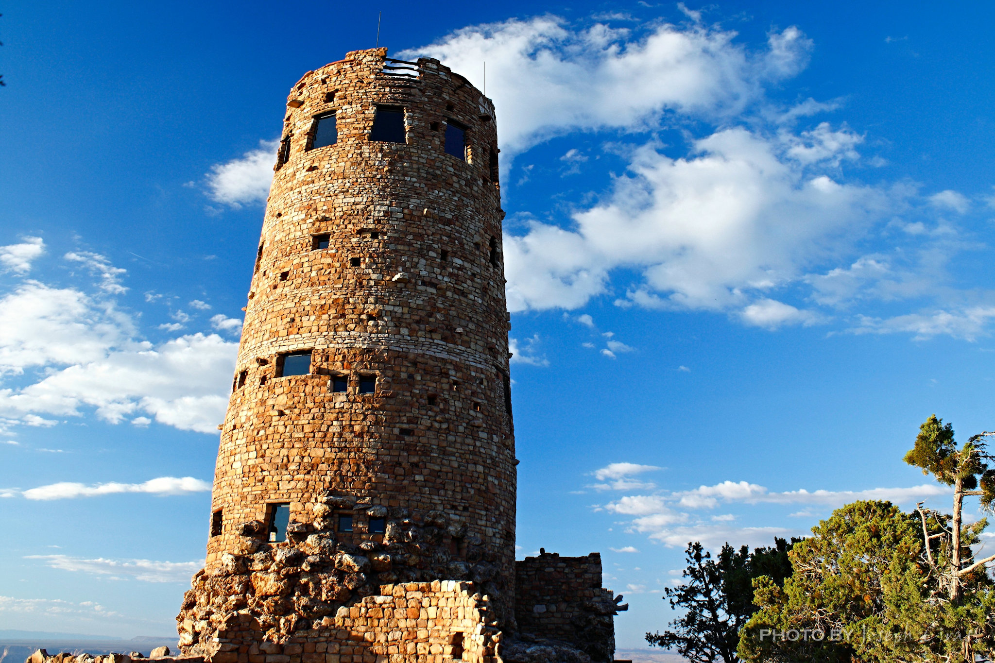
Sunday, 03/06/2022: Posted photo — Desert View Watchtower.
Settings: Canon EOS DIGITAL REBEL XS, ISO 200, f/5.6, 1/100 s, 20 mm.
Desert View Watchtower, South Rim Grand Canyon National Park.
We arrived at the South Rim of the Grand Canyon just before sunset. We spent the last couple of nights camping and hiking along the North Rim of the Grand Canyon and would be spending time on the South Rim. I have been to the Canyon before, but never from this entrance.

From the National Parks Service: “A National Historic Landmark, the Watchtower was constructed in 1932.The design by Mary Colter, is based on the architecture of the Ancestral Puebloan people of the Southwest. This particular tower was patterned after those found at Hovenweep and the Round Tower of Mesa Verde.”
We have been to Hovenweep and to Mesa Verde and agree with that statement.
Monday, 03/07/2022: Posted photo — Four Corners Monument Navajo Tribal Park.
Settings: Canon EOS DIGITAL REBEL XS, ISO 200, f/16, 1/400 s, 49 mm.
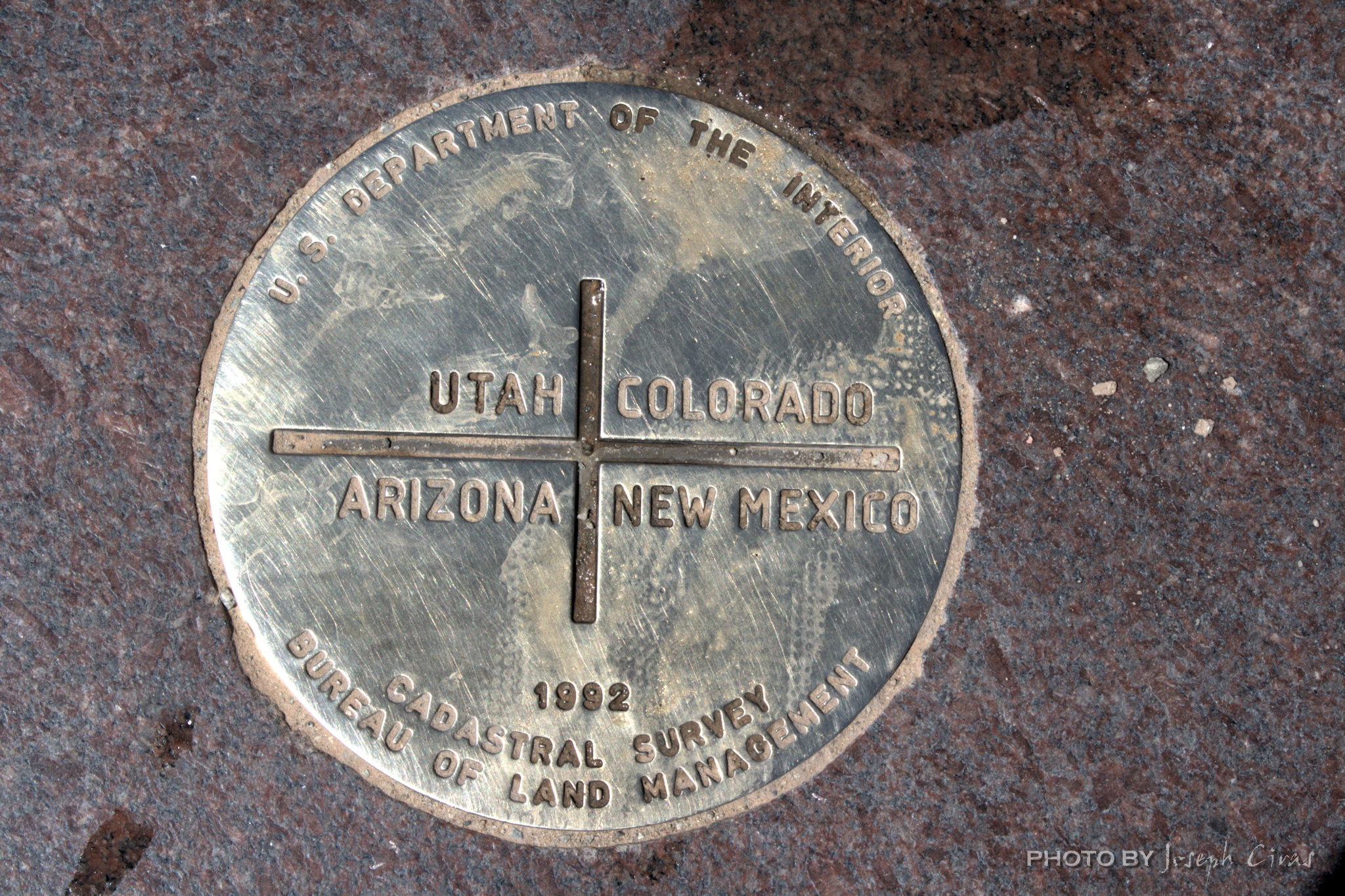
The Four Corners Monument marks the quadripoint in the Southwestern United States where the states of Arizona, Colorado, New Mexico, and Utah meet. It is the only point in the United States shared by four states.
Tuesday, 03/08/2022: Posted photo — Great Sand Dunes National Park and Preserve.
Settings: Canon EOS DIGITAL REBEL XS, ISO 200, f/13, 1/800 s, 90 mm.
Great Sand Dunes National Park and Preserve, Mosca, CO.
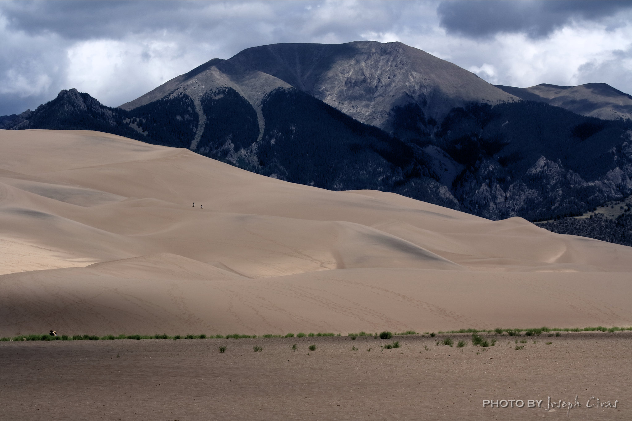
One of the amazing things about the Great Sand Dunes is that you can see them from miles away. As you turn off the main road and head towards the dunes, they are right in front of you. We spent the day hiking the dunes pretending we were in a desert. When you look at this photo, you see a couple of dots in the sand. Those are people. The sand was hot. According to Park Service, the sand surface can reach 150 degrees F (65 degrees C) on a summer afternoon or drop to minus 20 degrees F (minus 29 degrees C) on a winter night. It was close to the 150 degrees when we were walking on the sand.
From the National Parks Service: “The tallest dunes in North America are the centerpiece in a diverse landscape of grasslands, wetlands, forests, alpine lakes, and tundra. Great Sand Dunes National Park is a complex geologic story going back millions of years. Intense volcanic activity built the San Juan mountain range to the west of the modern day dunes and tectonic activity raised the Sangre de Cristo Mountains to the north and east.”
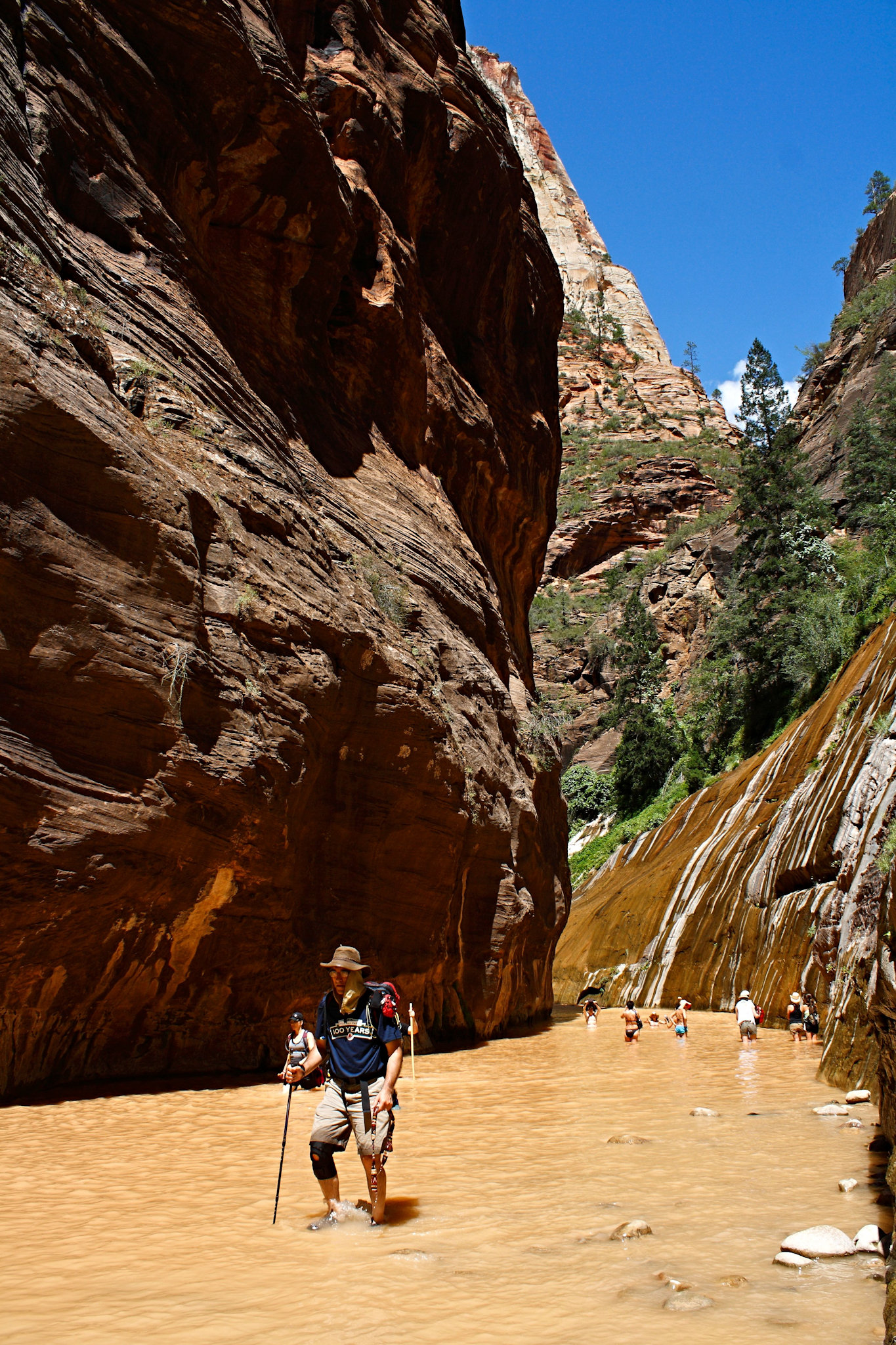
Wednesday, 03/09/2022: Posted photo — Hiking the Narrows.
Settings: Canon EOS DIGITAL REBEL XS, ISO 200, f/9, 1/2050 s, 18 mm.
Zion National Park Springdale, UT.
This is a photo my wife took of me as we were hiking the Narrows in Zion National Park. It was a refreshing hike on a hot summer day. When you hike the Narrows, you need to be very aware of the weather. Because it is so narrow, there is no escape route if there happens to be a flash flood.

From the National Parks Service: “The Narrows is the narrowest section of Zion Canyon. This gorge, with walls a thousand feet tall and the river sometimes just twenty to thirty feet wide, is one of the most popular areas in Zion National Park. You can see The Narrows by hiking along the paved, wheelchair accessible Riverside Walk for one mile from the Temple of Sinawava. If you wish to see more, you will be walking in the Virgin River. This can involve wading upstream for just a few minutes or it can be an all day hike.”
Thursday, 03/10/2022: Posted photo — NRAO Very Large Array.
Settings: Canon EOS DIGITAL REBEL XS, ISO 200, f/10, 1/800 s, 165 mm.
NRAO Very Large Array, Magdalena, NM.
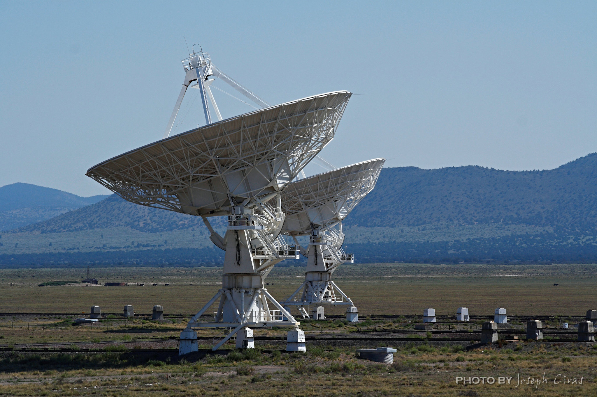
One of the most interesting places to visit. As you can see from the description below, the array can be very large. When we visited, there were 26 radio antennas pointing in one direction and one pointing in an opposite direction. We thought that was strange. They told up that the odd one was scanning the sky.
“The Very Large Array, one of the world’s premier astronomical radio observatories, consists of 27 radio antennas in a Y-shaped configuration on the Plains of San Agustin fifty miles west of Socorro, New Mexico. Each antenna is 25 meters (82 feet) in diameter. The data from the antennas is combined electronically to give the resolution of an antenna 36 km (22 miles) across, with the equivalent sensitivity of a dish 130 meters (422 feet) in diameter.” — http://www.vla.nrao.edu/
Friday, 03/11/2022: Post photo — Owachamo Bridge.
Settings: Canon EOS DIGITAL REBEL XS, ISO 100, f/7.1, 1/125 s, 18 mm.
Owachamo Bridge, Natural Bridges National Monument, UT.
Owachomo is the smallest and thinnest of the three natural bridges in the National Monument and is commonly thought to be the oldest. We had a great hike out to the bridge.
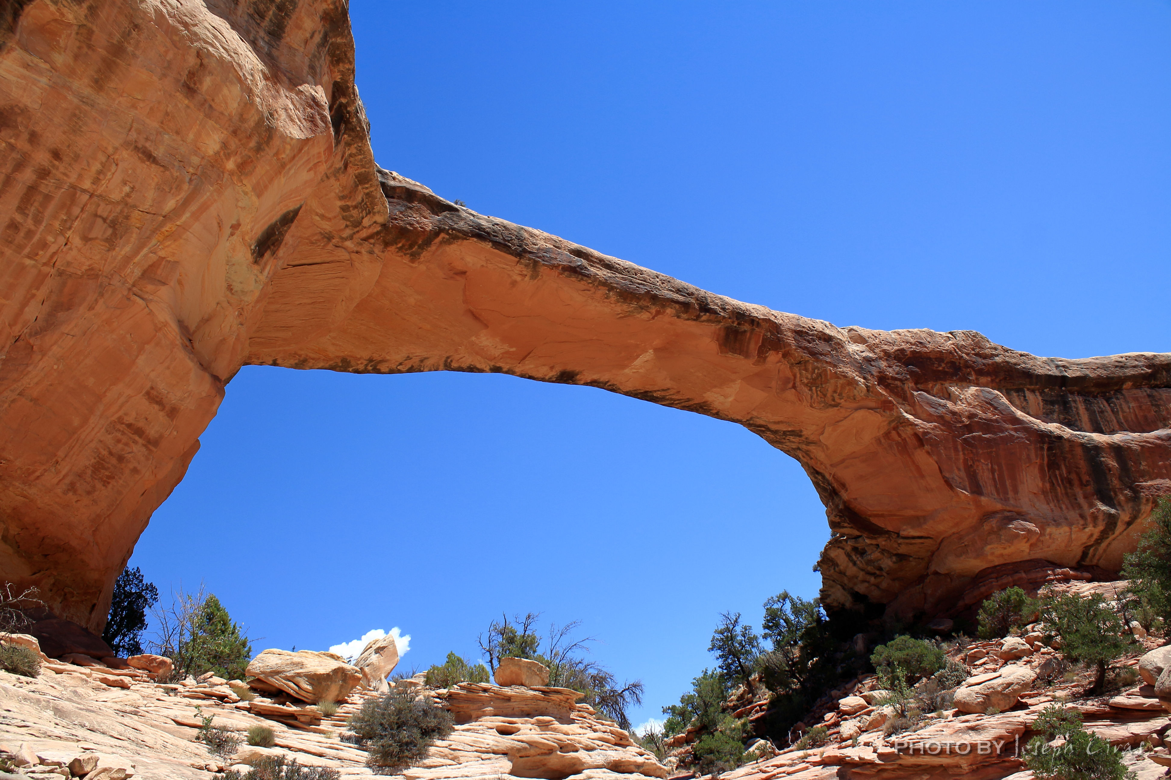
We like to travel to the lesser know parks. These parks are lesser know mostly because of location. They are not close to any major city or town. We like to say it is great to have a park to ourselves.
Dimensions
Height: 106 feet (32 meters)
Span: 180 feet (55 meters)
Width: 27 feet (8 meters)
Thickness: 9 feet (3 meters)
Saturday, 03/12/2022: Post photo — Spruce Tree House.
Settings: Canon EOS DIGITAL REBEL XS, ISO 200, f/5, 1/50 s, 20 mm.
Spruce Tree House, Mesa Verde National Park, CO.
From the National Park Service: “Spruce Tree House, the third largest cliff dwelling (Cliff Palace and Long House are larger), was constructed between about 1211 and 1278 CE by the ancestors of the Pueblo peoples of the Southwest. The dwelling contains about 130 rooms and 8 kivas (kee-vahs), or ceremonial chambers, built into a natural alcove measuring 216 feet (66 meters) at greatest width and 89 feet (27 meters) at its greatest depth. It is thought to have been home for about 60 to 80 people.”
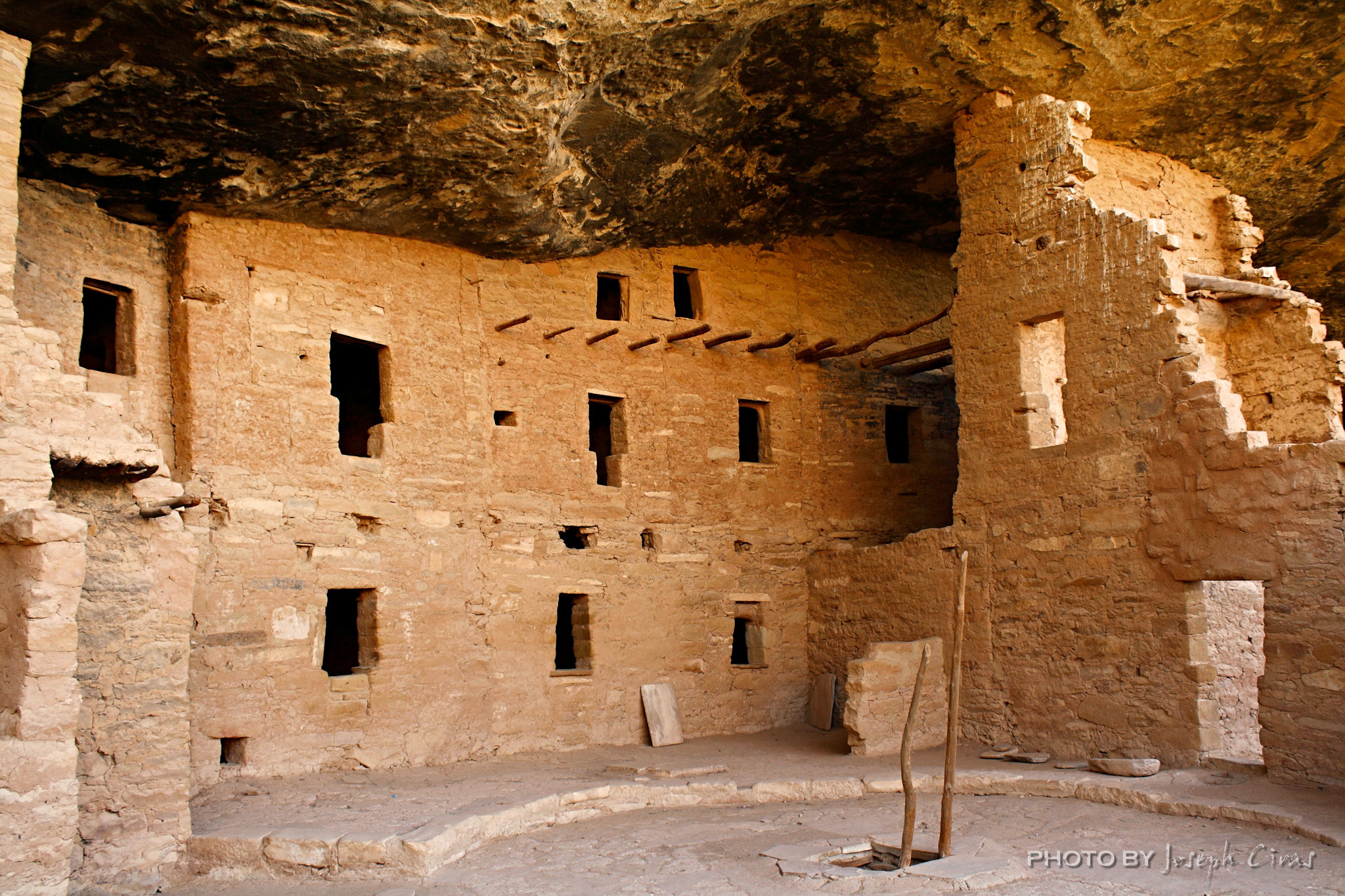
We were lucky enough to get to the park prior to 2012 during one of our northern National Park tours. We were able to explore the Spruce Tree House. We went into some of the rooms and into the kivas. Due to the unstable cliff about the Spruce Tree House, the entire site was closed to the public in October 2015. We have visited the park since then since I have a relative that works at the park. We were able to obtain permits to do some backcountry hiking with my relative guide to some dwellings that are off limits to the public.
That is all for now. Until next week, be safe.
“Sumens imagines consolatur et inspirat me.”